


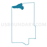
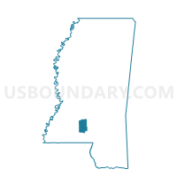
Oma Voting District, Lawrence County, Mississippi
About
Outline

Summary
| Unique Area Identifier | 605993 |
| Name | Oma Voting District |
| County | Lawrence County |
| State | Mississippi |
| Area (square miles) | 18.39 |
| Land Area (square miles) | 18.08 |
| Water Area (square miles) | 0.31 |
| % of Land Area | 98.32 |
| % of Water Area | 1.68 |
| Latitude of the Internal Point | 31.71866510 |
| Longtitude of the Internal Point | -90.16197480 |
Maps

Graphs
Select a template below for downloading or customizing gragh for Oma Voting District, Lawrence County, Mississippi


Neighbors
Neighoring Voting District (by Name) Neighboring Voting District on the Map
- Georgetown South Voting District, Copiah County, MS
- Little Bahala Voting District, Lincoln County, MS
- New Hebron Voting District, Lawrence County, MS
- Sontag Voting District, Lawrence County, MS
- Stringer Voting District, Lawrence County, MS
- Strong Hope-Union Voting District, Copiah County, MS
- Wanilla Voting District, Lawrence County, MS
Top 10 Neighboring County Subdivision (by Population) Neighboring County Subdivision on the Map
- District 2, Copiah County, MS (7,165)
- District 2, Lincoln County, MS (6,962)
- District 2, Lawrence County, MS (2,645)
- District 4, Lawrence County, MS (2,569)
Top 10 Neighboring Unified School District (by Population) Neighboring Unified School District on the Map
- Copiah County School District, MS (18,369)
- Lincoln County School District, MS (16,246)
- Lawrence County School District, MS (12,929)
Top 10 Neighboring State Legislative District Lower Chamber (by Population) Neighboring State Legislative District Lower Chamber on the Map
- State House District 62, MS (28,658)
- State House District 92, MS (26,069)
- State House District 91, MS (20,672)
Top 10 Neighboring State Legislative District Upper Chamber (by Population) Neighboring State Legislative District Upper Chamber on the Map
Top 10 Neighboring 111th Congressional District (by Population) Neighboring 111th Congressional District on the Map
Top 10 Neighboring Census Tract (by Population) Neighboring Census Tract on the Map
- Census Tract 9505, Copiah County, MS (6,087)
- Census Tract 9602, Lawrence County, MS (4,551)
- Census Tract 9601, Lawrence County, MS (4,249)
- Census Tract 9501, Lincoln County, MS (4,093)
Top 10 Neighboring 5-Digit ZIP Code Tabulation Area (by Population) Neighboring 5-Digit ZIP Code Tabulation Area on the Map
- 39083, MS (10,626)
- 39191, MS (8,074)
- 39654, MS (5,635)
- 39663, MS (3,080)
- 39140, MS (2,250)
- 39665, MS (1,196)